Ancient World Atlas
WELCOME TO ATLAS OF THE ANCIENT WORLD
A Fascinating Journey Into Antiquity
Explore The Ancient World On The Map
Borders of the Roman Empire and more
(TR)
ANTİK DÜNYANIN ATLASINA HOŞ GELDİNİZ
Antik Çağa Büyüleyici Bir Yolculuk
Harita Üzerinde Antik Dünyayı Keşifedin
Roma İmparatorluğu'nun sınırları ve daha fazlası
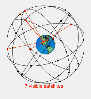
GPS, Global Positioning System ; It is an abbreviation consisting of the initials of the words meaning global positioning system in Turkish. What is GPS? Let's take a closer look at the question; They are devices that can find their position on Earth thanks to highly accurate clock signals from at least 3 (at least 4 if altitude information is included) GPS satellites. GPS is a global positioning service developed by the United States. In addition to GPS, there are also global positioning systems such as GLONASS developed by Russia, IRNSS developed by India, BeiDou (BDS) developed by China and Galileo developed by European countries. Global navigation satellite system (GNSS) to all these systems is given the name, but because it is the first system to come out, most of these systems are often referred to as GPS.
GPS Satellites
As of today, USA's GPS and Russia's GLONASS systems can be used actively. BeiDou and Galileo systems continue to be developed to be operational globally in 2020. Working principle of GPSIt is as follows: GPS satellites in Earth orbit contain highly accurate atomic clocks. These clocks work in sync with other satellites and clocks on earth, and any deviations are corrected daily. Satellites continuously send their position in orbit and this sensitive time information to the Earth. When any GPS receiver in the world is operated, it needs these signals from at least 3 of the GPS satellites in the coverage area, and the GPS receiver, which can learn the distance from each satellite by finding how much the incoming clock information deviates from the absolute time, can calculate its position on the earth with this information. Navigationour devices and mobile phones can show our current location on the map by using this location information and calculate the necessary route information to reach the destination we have chosen, by calculating the shortest route, the most economical way, etc. can choose. For this process, map information must be installed in the device. On mobile phones, on the other hand, map information can be pre-loaded and the most up-to-date map information can be obtained through an internet connection, as well as opportunities such as instant traffic information.
In electronic projects, GPS is frequently used in location tracking, precision speed measurements and UAV (drone) projects. Most GPS receivers also work in compliance with the other standards mentioned in the first paragraph. You can reach our article on GY-NEO6MV2 GPS Module Usage with Arduino Uno, which is on our blog as an example project, from the link here .